
When Wildfires Become Climate Fire
Wildfires are a natural part of our global ecosystem. They serve a regenerative role and are nature’s way of stimulating new growth and releasing nutrients on forest floors. Wildfires are not going away and will continue to occur on this planet. They, however, turn from being a normal process of nature to a destructive force threatening civilization when fires occur with increased frequency in densely populated areas and cannot be controlled.
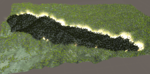
Spark takes current knowledge of fire behaviour and combines it with state-of-the-art simulation science to predict bushfire spread.
The forecast for North America is that large scale wildfires will increase in intensity and frequency for the coming decade. According to the Fourth National Climate Assessment of the US, the “annual area burned in the Western U.S., for example, could increase two to six times what it is today.” Driven by increasingly dramatic cycles of drought and rain, countries are rethinking how to address wildfires. While wildfires prose dramatic health and economic risks to the population, of equal concern is the contribution to climate disruption from the carbon dioxide released.
At the time this article was written there were 1,817 active fires in the United States. The consensus among scientists around the world and government leaders in affected regions is these are not wildfires as nature intended them, these are climate fires.
The increasing propensity of these fires is largely driven by human housing encroaching deeper into wildland-urban fire interfaces. In response, researchers and scientists from multiple disciplines are collaborating on how to manage and prevent the destruction of climate fires.
One of the tools being explored is the use of sophisticated modeling and simulation to understand how fires might behave based on the underlying terrain, wind, and ground cover. That information can inform fire crews, law enforcement and emergency management on the rate of spread, direction and which locations are at most risk.
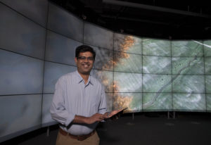
Dr Mahesh Prakash led the team behind Spark, our bushfire prediction modelling tool.
CSIRO’s data and digital specialist arm, Data61, developed SPARK, an open framework which combines our current knowledge of fire behaviour with state-of-the-art simulation science to produce predictions, statistics and visualisations of bushfire spread. Users can design custom fire propagation models by incorporating various input, processing and visualization components, such as meteorological and geographical data, each tailored for wildfire modelling. The software includes the 3D visualization of hot spots and overall fire. With the ability to visualize hundreds of thousands of individual hot spots and model wind interaction and local conditions, emergency management can better understand how hot spots may form, where to build fire lines and how best to deploy limited human and equipment resources. The firebrand models are entirely user-defined to allow complete flexibility in creating, testing and deploying firebrand models.
Drawing upon the experiences of Australia and California, two regions plagued by wildfires, CSIRO’s Data61 scientists have collaborated with San Jose State University and wildfire research start-ups to better understand wildfire behavior based on local vegetation and weather. According to Dr Mahesh Prakash, who leads the natural systems modelling group at Data61, SPARK can run fire predictions for any given location.
Such predictions play a critical role at the frontline, supporting decisions on where best to deploy often limited resources. Wildfire researchers can also use it to understand different types of fire models, Dr Prakash said.
As wildfires continue to intensify each year, SPARK and other innovations can increasingly inform more effective evacuation route planning and the timely issuing of evacuation warnings and orders. The ability to better understand how wildfire behavior impacts critical infrastructure based on past fire events enables local governments and utilities to do a better job of protecting these sites.